Slann
Scalenex
Keeper of the Indexes
- Messages
- 11,543
- Likes Received
- 20,518
- Trophy Points
- 113
Redrawing the Map, Part One
I have much graph paper to play with. I'm working on Scarterra 1.0 right now, the Pangea-like continent.
Once I get this finalized I'm going to go to Scarterra 2.0 (after the First Unmaking) and Scarterra 3.0 (after the Second Unmaking.)
My goal is to break the Pangea-like continent into pieces that would fit back together relatively cleanly making it obvious that the main continents are pieces of a greater, though I do plan to rough up the coastlines a bit with peninsulas and inlets, so the new configuration won't fit together too cleanly.
My graph paper is 26 x 54 squares, but I like simple math and I already determined that ScarAquaTerra is going to be three times as "long" as it is "tall." I like simple math, so I'm allocating 48 squares on the x-axis and 16 squares on the y axis. The equator is going to be "8." The Prime Meridian is going to be 24 which will bisect Mera's Lake on Scarterra 1.0 which is going to be at the dead center of my graph paper.
You'll notice on my earlier sketch that Mera's Lake is actually north of the equator. I'm probably going to change this on mynew map, unless someone provides me with a compelling reason why Mera's lake would gradually migrate north between Scarterra 1.0 and Scarterra 3.0.
Mera's Lake would not have been called "Mera's Lake" during the First Age. It was only during Scarterra 2.0 that people began to associate Mera's Lake with Mera that forcefully. The lake was certainly called something else, but I'm keeping the name Mera's Lake for simplicity.
The continents are probably going to look largely the same. In Scarterra 1.0 Mera's Lake is going to be the dead center. Since Scarterra 1.0 was basically a pastoral paradise to lure mortals into being docile farm animals, to me it makes sense that the land would be fairly symmetrical, aesthetically pleasing, and above all, peaceful and safe...(until Turoch eats you of course).
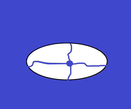
I promise I'll scan some of my graph paper sketches soonish, but in the meantime I attached some crude facsimiles I made on Microsoft Paint of of Scarterra 1.0.
(if you check this out in the first twenty minutes of me posting this, there are probably technical difficulties with my attachments, because that's how I roll)
Whether I make Mera's Lake a circle or an oval the net result is that my rough sketches end up looking like an eyeball with a tiny pupil to me. Instead of resisting the eye imagery, I plan to lean into it. I'm probably going to name the primordial landmass something eye based instead of Pangea. "Turoch's Eye" or the "Primordial Eye" or "The Great Earthen Eye".
I could just leave the Eyegea as flat rough oval with a lake in the middle forming an isolated pupil, or I could give the pupil an iris. Maybe a mountain or hill range. Maybe a plateau. Maybe a thick forest.
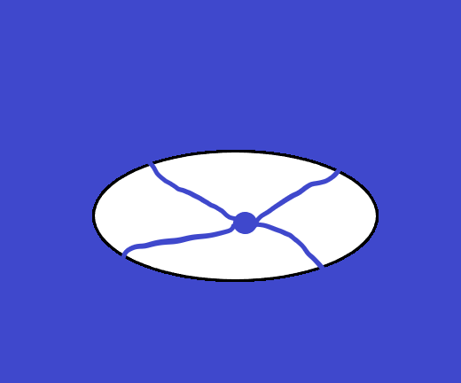
Besides adding an Iris, another option is to make Turoch's Eye "cry." In other words adding major rivers. My first instinct is to bisect the world in fairly close to equally sized quarters. This would lend Scarterra 1.0 looking very to @Lord Agragax of Lunaxoatl's fantasy realm of Escalonia where the land is thematically split between northeast, northwest, southeast, and southwest sections.
Another option I am toying with is what I call "The Beholder Model" Mera's Lake is the primary source of fresh water in the interior BUT there are lots of satellite lakes (which sort of look like smaller eyes) which feed into smaller rivers and streams (which sort of look like eye stalks). Most of these lakes and rivers would be claimed by the sea, dried up, or rerouted on Scarterra 3.0 but they would leave some kind of primordial mark on the land. Among other things, any land that exists where a mighty ancient lake used to be would be saturated with the magical essence of water, so water based magic would be easy there, it would probably rain a lot, and humanoids in the area would manifest water based racial traits.
Since Beholders are nightmarish aberrations in Dungeons and Dragons, I'm tempted to rewrite my history a little bit to make Beholders sort of a primordial rival to the gods. If the original version of Scarterra looked like a bunch of eyeballs, or even just one eye they could use this as justification for their belief that they used to rule the world (or at least were meant to rule the world and denied their rightful prize).
I'm open to suggestions to make Scarterra 1.0 more interesting and more believable. While Scarterra 3.0 is probably going to mostly resemble the first map I made (reposted above), this is not set in stone. It will not hurt my feeling if the new map ends up looking substantially different. I want Scarterra 3.0 to be a logical evolution of Scarterra 1.0.
Since the main force causing Eyegea to break into smaller pieces is because earth elementals are going to war with air, fire, and above all else, water elementals; it is logical that continental fractures occur where the great rivers and lakes are. Unless someone can give me a SCIENCE argument otherwise.
That's not going to be the only determinate of land masses. While the net effect of the First Unmaking is that large portions of land are claimed by the sea, various "marches" of earth elementals will create new mountain ranges and where these mountain ranges hit the sea the mountains become island chains.
I also need to figure out where the most dragon friendly areas of Scarterra 1.0 are because these are the places lucrative First Age ruins are likely to be, though thousands of years of magical chaos (and thousands of years of looters) could move artifacts and relics far from their original locations.
As I work on refining my sketches, what direction do you think I should go with. Is the eyeball a good motiff or should I use something else? I'm sort of operating on the assumption that eyeball is acceptable, but if it's not, let me know.
Should the eyeball have an iris? What about rivers and smaller lakes? Any thoughts on how SCIENCE dictates Eyegea would logically break apart?
Going back to my 16 x 48 grid (768 squares). If I go on a 4,000 x 12,000 mile world, that would make each square a 250 x 250 square. That's roughly as big as the surface area of Mars. If I want to make ScarAquaTerra roughly as big as Earth, than I up the squares to being 500 x 500.
Climate is going to be determined primarily by the y axis (mountains, proximity to oceans and magical nodes of elemental power will also impact climate a little bit). 0 to 2.5 and 13.5 to 16 is going to be where the arctic biome is. 6 to 10 is going to be where the tropical biome is. 2.5 to 6 and 10 to 13.5 is going to be my temperate zones. So 5 squares (32%) of arctic, 4 squares (25%) of tropical, and 7 squares (43%) of temperate. Not in set in stone, but this is a good baseline for now.
Off the edge of the map is going to be about 10-100 miles of snow covered ice vaguely similar to the North Pole. Beyond this about 1-20 miles of the Near Void. The Near Void is miserable, but mortals can survive there for a few days at least without magical assistance. Past this, depending on which magical theoretician or theologian you ask, there is somewhere between a 100 and infinity miles of the Far Void, where a mortal will die in under two minutes and have their soul obliterated in under ten minutes without powerful magic.
My goal is for most of Scarterra's land mass is going to stretch over the temperate zone. Land in the tropical zone is going to be relatively rare. Land in the artic zones is going to be moderately common.
Most of Scaraqua's most habitable territory is going to be in the tropical zone, especially the shallows. Anything ocean that is close to land masses or areas that used to be land during Scarterra 1.0 is going to be fairly shallow, which is going to biased in favor of the tropical zone because the primordial continent of Eyegea was centered around the equator.
Scaraqua doesn't have a lot of habitable temperate waters. They have a fair amount of theoretically habitable arctic shallows, but these are unpopular places to live. The only real reasons Scaraquans normally come here is if they are outcasts or criminals hoping to disappear though a few adventurers may swim here because the polar waters of Scaraqua house most of ScarAquaTerra's remaining relics and treasures left over from the First Age.
We'll see how bored I get counting squares, but my current vision is that Scarterra 1.0 will be about two thirds land and one third water, while Scarterra 3.0 will possess a roughly 1:1 water to land ratio.
Scarterra 2.0 is going to look virtually identical to Scarterra 3.0. The main difference is that Scarterra 2.0 has the continent of Colassia and Scarterra 3.0 has East Colassia and West Colassia. Scarterra 3.0 has a lot more deserts, swamps and other desolate spots where Void Demons blighted the land (or sea floor), but the addition of blighted land doesn't actually reshape the continents much.
I messed around with graph paper a bit to make World Maps in miniature:
View attachment 62949
The top one represents your continents as you have currently sketched on an 8.5x11 sheet. With a blank piece of legal size paper stuck next to it. That results in a rectangular, unfolded, unrolled map that is real close to 3x as wide as it is tall.
The bottom one is an attempt to sketch the continent shapes stretched East-West, but left about the same North/South. It still leaves a big patch of empty Ocean. Pay no attention to those blue globs at the edges...they could be anything.
The total map size shown here is 25x8.5
I have much graph paper to play with. I'm working on Scarterra 1.0 right now, the Pangea-like continent.
Once I get this finalized I'm going to go to Scarterra 2.0 (after the First Unmaking) and Scarterra 3.0 (after the Second Unmaking.)
My goal is to break the Pangea-like continent into pieces that would fit back together relatively cleanly making it obvious that the main continents are pieces of a greater, though I do plan to rough up the coastlines a bit with peninsulas and inlets, so the new configuration won't fit together too cleanly.
My graph paper is 26 x 54 squares, but I like simple math and I already determined that ScarAquaTerra is going to be three times as "long" as it is "tall." I like simple math, so I'm allocating 48 squares on the x-axis and 16 squares on the y axis. The equator is going to be "8." The Prime Meridian is going to be 24 which will bisect Mera's Lake on Scarterra 1.0 which is going to be at the dead center of my graph paper.
You'll notice on my earlier sketch that Mera's Lake is actually north of the equator. I'm probably going to change this on mynew map, unless someone provides me with a compelling reason why Mera's lake would gradually migrate north between Scarterra 1.0 and Scarterra 3.0.
Mera's Lake would not have been called "Mera's Lake" during the First Age. It was only during Scarterra 2.0 that people began to associate Mera's Lake with Mera that forcefully. The lake was certainly called something else, but I'm keeping the name Mera's Lake for simplicity.
The continents are probably going to look largely the same. In Scarterra 1.0 Mera's Lake is going to be the dead center. Since Scarterra 1.0 was basically a pastoral paradise to lure mortals into being docile farm animals, to me it makes sense that the land would be fairly symmetrical, aesthetically pleasing, and above all, peaceful and safe...(until Turoch eats you of course).
I promise I'll scan some of my graph paper sketches soonish, but in the meantime I attached some crude facsimiles I made on Microsoft Paint of of Scarterra 1.0.
(if you check this out in the first twenty minutes of me posting this, there are probably technical difficulties with my attachments, because that's how I roll)
Whether I make Mera's Lake a circle or an oval the net result is that my rough sketches end up looking like an eyeball with a tiny pupil to me. Instead of resisting the eye imagery, I plan to lean into it. I'm probably going to name the primordial landmass something eye based instead of Pangea. "Turoch's Eye" or the "Primordial Eye" or "The Great Earthen Eye".
I could just leave the Eyegea as flat rough oval with a lake in the middle forming an isolated pupil, or I could give the pupil an iris. Maybe a mountain or hill range. Maybe a plateau. Maybe a thick forest.
Besides adding an Iris, another option is to make Turoch's Eye "cry." In other words adding major rivers. My first instinct is to bisect the world in fairly close to equally sized quarters. This would lend Scarterra 1.0 looking very to @Lord Agragax of Lunaxoatl's fantasy realm of Escalonia where the land is thematically split between northeast, northwest, southeast, and southwest sections.
Another option I am toying with is what I call "The Beholder Model" Mera's Lake is the primary source of fresh water in the interior BUT there are lots of satellite lakes (which sort of look like smaller eyes) which feed into smaller rivers and streams (which sort of look like eye stalks). Most of these lakes and rivers would be claimed by the sea, dried up, or rerouted on Scarterra 3.0 but they would leave some kind of primordial mark on the land. Among other things, any land that exists where a mighty ancient lake used to be would be saturated with the magical essence of water, so water based magic would be easy there, it would probably rain a lot, and humanoids in the area would manifest water based racial traits.
Since Beholders are nightmarish aberrations in Dungeons and Dragons, I'm tempted to rewrite my history a little bit to make Beholders sort of a primordial rival to the gods. If the original version of Scarterra looked like a bunch of eyeballs, or even just one eye they could use this as justification for their belief that they used to rule the world (or at least were meant to rule the world and denied their rightful prize).
I'm open to suggestions to make Scarterra 1.0 more interesting and more believable. While Scarterra 3.0 is probably going to mostly resemble the first map I made (reposted above), this is not set in stone. It will not hurt my feeling if the new map ends up looking substantially different. I want Scarterra 3.0 to be a logical evolution of Scarterra 1.0.
Since the main force causing Eyegea to break into smaller pieces is because earth elementals are going to war with air, fire, and above all else, water elementals; it is logical that continental fractures occur where the great rivers and lakes are. Unless someone can give me a SCIENCE argument otherwise.
That's not going to be the only determinate of land masses. While the net effect of the First Unmaking is that large portions of land are claimed by the sea, various "marches" of earth elementals will create new mountain ranges and where these mountain ranges hit the sea the mountains become island chains.
I also need to figure out where the most dragon friendly areas of Scarterra 1.0 are because these are the places lucrative First Age ruins are likely to be, though thousands of years of magical chaos (and thousands of years of looters) could move artifacts and relics far from their original locations.
As I work on refining my sketches, what direction do you think I should go with. Is the eyeball a good motiff or should I use something else? I'm sort of operating on the assumption that eyeball is acceptable, but if it's not, let me know.
Should the eyeball have an iris? What about rivers and smaller lakes? Any thoughts on how SCIENCE dictates Eyegea would logically break apart?
Going back to my 16 x 48 grid (768 squares). If I go on a 4,000 x 12,000 mile world, that would make each square a 250 x 250 square. That's roughly as big as the surface area of Mars. If I want to make ScarAquaTerra roughly as big as Earth, than I up the squares to being 500 x 500.
Climate is going to be determined primarily by the y axis (mountains, proximity to oceans and magical nodes of elemental power will also impact climate a little bit). 0 to 2.5 and 13.5 to 16 is going to be where the arctic biome is. 6 to 10 is going to be where the tropical biome is. 2.5 to 6 and 10 to 13.5 is going to be my temperate zones. So 5 squares (32%) of arctic, 4 squares (25%) of tropical, and 7 squares (43%) of temperate. Not in set in stone, but this is a good baseline for now.
Off the edge of the map is going to be about 10-100 miles of snow covered ice vaguely similar to the North Pole. Beyond this about 1-20 miles of the Near Void. The Near Void is miserable, but mortals can survive there for a few days at least without magical assistance. Past this, depending on which magical theoretician or theologian you ask, there is somewhere between a 100 and infinity miles of the Far Void, where a mortal will die in under two minutes and have their soul obliterated in under ten minutes without powerful magic.
My goal is for most of Scarterra's land mass is going to stretch over the temperate zone. Land in the tropical zone is going to be relatively rare. Land in the artic zones is going to be moderately common.
Most of Scaraqua's most habitable territory is going to be in the tropical zone, especially the shallows. Anything ocean that is close to land masses or areas that used to be land during Scarterra 1.0 is going to be fairly shallow, which is going to biased in favor of the tropical zone because the primordial continent of Eyegea was centered around the equator.
Scaraqua doesn't have a lot of habitable temperate waters. They have a fair amount of theoretically habitable arctic shallows, but these are unpopular places to live. The only real reasons Scaraquans normally come here is if they are outcasts or criminals hoping to disappear though a few adventurers may swim here because the polar waters of Scaraqua house most of ScarAquaTerra's remaining relics and treasures left over from the First Age.
We'll see how bored I get counting squares, but my current vision is that Scarterra 1.0 will be about two thirds land and one third water, while Scarterra 3.0 will possess a roughly 1:1 water to land ratio.
Scarterra 2.0 is going to look virtually identical to Scarterra 3.0. The main difference is that Scarterra 2.0 has the continent of Colassia and Scarterra 3.0 has East Colassia and West Colassia. Scarterra 3.0 has a lot more deserts, swamps and other desolate spots where Void Demons blighted the land (or sea floor), but the addition of blighted land doesn't actually reshape the continents much.


")


